UgCS for DJI
Description of UgCS for DJI
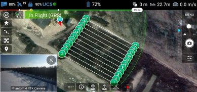
UgCS for DJI is an application designed to facilitate the connection between DJI drones and the UgCS desktop platform, enabling users to execute various automated drone survey missions. This app is particularly useful for those who require precise planning and execution of tasks such as AreaScan, Photogrammetry, Corridor Mapping, and Vertical (Facade) scans. The UgCS for DJI app is available for the Android platform and allows users to download it for seamless integration with their DJI drones.
The application supports a wide range of DJI drones, including models such as the M600, M300, M200 series, M100, and the Mavic series, among others. This compatibility ensures that a broad spectrum of users can utilize the app regardless of the specific drone model they own. With its robust features, the app enables users to upload pre-planned missions from the UgCS desktop to their drones, ensuring that all necessary parameters and routes are accurately set before launching a flight.
Users can initiate uploaded missions either manually or in auto-mode, providing flexibility depending on the mission requirements. The manual flight mode allows for real-time control, enabling operators to navigate their drones with precision while capturing images or videos. The app also includes a flight simulator, which provides a risk-free environment for users to practice and familiarize themselves with the drone's controls and flight dynamics before actual missions.
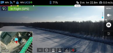
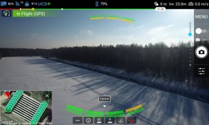
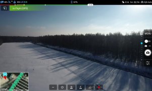
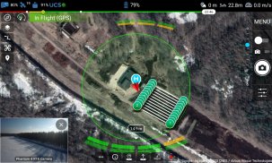
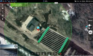
Live HD camera view is another significant feature of UgCS for DJI. This feature permits users to stream the camera feed directly to the UgCS desktop, offering real-time visuals of the drone's surroundings. This capability is essential for various applications, including surveying and inspection, where immediate visual feedback can influence operational decisions. Additionally, users can manage camera settings, such as gimbal pitch and yaw, directly through the app, enhancing the control over the aerial imagery captured during missions.
Telemetry data is readily accessible within the app, allowing users to monitor critical flight information such as altitude, speed, and battery status. This transparency is crucial for effective mission management, as it enables operators to make informed decisions based on current flight conditions. The app also supports both metric and imperial units, accommodating a diverse user base with varying measurement preferences.
A unique aspect of UgCS for DJI is its ability to reset the home position of the drone. This feature is particularly useful in dynamic environments or when the drone has been moved from its original launch location. Users can also command their drones to return to the home position, ensuring safety and control during missions, especially in situations where the drone may be out of sight.
For users looking to perform extensive aerial surveys or inspections, the UgCS desktop platform enhances the capabilities of the app. With tools for automated mission planning, built-in photogrammetry, and map customization, UgCS provides a comprehensive solution for drone operators. The platform also includes features for geotagging and battery exchange options for long routes, making it an effective tool for various aerial applications.
The UgCS for DJI app is designed to improve operational efficiency for drone pilots engaged in professional and recreational flying. By combining automated mission planning with the ability to control and monitor flights in real time, the app serves as a reliable resource for efficient drone operation. Whether for capturing stunning aerial photography or conducting detailed surveys, the app provides the necessary tools to manage and execute missions effectively.
In addition to its operational functionalities, the app is also user-friendly, making it accessible for both seasoned drone operators and those new to the technology. The straightforward interface allows users to navigate through various options without unnecessary complexity, ensuring that they can focus on their tasks at hand.
As a part of the UgCS ecosystem, the UgCS for DJI app complements the capabilities of its desktop counterpart, providing a seamless transition between planning and execution. This integration is crucial for users who require a high level of precision and reliability in their drone operations.
With its wide-ranging features and compatibility with numerous DJI drones, UgCS for DJI stands out as a valuable application for anyone involved in drone surveying and aerial photography. The combination of automated mission uploads, real-time telemetry, and camera control creates a robust tool that enhances the overall flying experience for users.
For further details about the UgCS platform and to download the latest version of UgCS, visit https://ugcs.com/download. Control your drones effectively with UgCS at https://ugcs.com.
UgCS for DJI - APK Information
APK Version: 2.39.2524Package: com.ugcs.android.vsm.djiLatest Version of UgCS for DJI
Other versions


Apps in the same category


You may also like...